

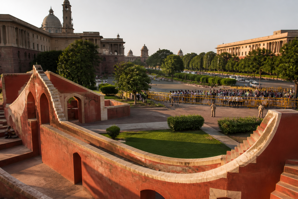
Jantar Mantar in Delhi is often treated as either an astronomical monument or a familiar backdrop for political demonstrations. Its longer history shows something more significant: the capital’s protest spaces have been shaped by the same forces that organise its roads, government district and public institutions—crowd size, proximity to power, traffic management and administrative control.
The observatory was built around 1724 by Maharaja Sawai Jai Singh II of Jaipur with permission from Mughal emperor Muhammad Shah ‘Rangeela’. Its original purpose was scientific. Jai Singh, who was a statesman, scholar, architect and planner, drew on eastern and western astronomical traditions and established observatories in Delhi, Jaipur, Ujjain, Mathura and Varanasi. The structures were intended to improve the accuracy of astronomical calculations, not to host political gatherings.
That original function is still visible in the monument’s physical form. Jantar Mantar is an open-air observatory containing 13 large instruments built with bricks and lime. The Samrat Yantra could measure the time of day to half a second, while the Misra Yantra could track the shortest and longest days of the year and measure equinoxes. The Jai Prakash Yantra consists of two large stone bowls sunk into the ground, and the Ram Yantra uses a central pillar and circular structure to calculate the position of stars.
The scale of these instruments was central to their purpose. Large, permanent structures enabled calculations that smaller instruments of the period could not achieve. In that sense, Jantar Mantar was an early example of infrastructure built to make knowledge measurable in public space. Its structures converted the sky into an accessible physical map, allowing astronomical observation to take place without a telescope.
The observatory also changed materially over time. The royal family of Jaipur carried out major renovations in 1852 and 1910. The instruments, originally described as having a shining white limestone appearance, later acquired their current crimson red colour. A drainage system was installed to prevent rainwater from collecting around the structures and damaging them. These details show that the site’s survival has depended not only on its historic design but also on continuing maintenance.
Its political identity emerged much later. In 1988, a farmers’ protest lasting nearly a week brought tens of thousands of people to the Boat Club lawn near India Gate and Rajpath, now Kartavya Path. The lawn’s location near government buildings, combined with the size of the gathering, alarmed the authorities. After the demolition of the Babri Masjid in December 1992, protests were moved to Jantar Mantar, almost two kilometres away, according to the account by historian Anoushka Jain published in The Hindu.
The shift was not simply a change of address. It reflected how Delhi manages public assembly in relation to the central state. The Boat Club lawn placed very large crowds close to major government buildings and ceremonial avenues. Jantar Mantar offered a more contained setting: a linear road between Ashoka Road and Parliament Road. Police authorities considered its layout easier for crowd control and traffic management, making it a practical location for demonstrations.
That physical arrangement helps explain why the observatory became a protest landmark. A protest site is not only a legal or administrative designation. It is also a piece of urban infrastructure. Its width, access points, surrounding roads, distance from sensitive buildings and ability to accommodate police deployment all affect who can gather, how many people can attend and how visible a demonstration becomes.
The contradiction at the heart of Jantar Mantar is that the same spatial qualities that make it useful for protest also limit it. Its location in central Delhi gives demonstrations symbolic proximity to Parliament and government offices, while its contained form allows authorities to manage crowds more closely than they could at a large open lawn. The site therefore balances visibility with restriction, access with containment.
The Hindu account says Jantar Mantar was recently de-notified as Delhi’s official protest site, even as crowds gathered there demanding the resignation of Chief Election Commissioner Gyanesh Kumar. It also reports that the Ramlila Ground, Burari Ground and CBD Ground in East Delhi were designated for demonstrations. The supplied account does not provide the notification date, the issuing authority or the operational conditions attached to the new locations. Those details would be important for understanding whether the change represents a complete relocation of protest activity or a redistribution of demonstrations across the city.
The choice of replacement sites also raises a question about distance. Jantar Mantar’s political importance comes partly from its relationship with the central government district. Moving demonstrations to other grounds may make crowd management easier, but it can also change the relationship between protest and power. A designated ground can provide space for assembly while reducing the immediate visibility of demonstrators to the institutions they seek to address.
This is not an argument that one location is automatically better than another. It is a reminder that public space carries administrative meaning. When a city assigns protests to particular grounds, it is deciding more than where people may stand. It is determining how public disagreement enters the visual and physical field of governance, which roads are affected, which neighbourhoods bear the disruption and how close citizens can come to decision-making centres.
Jantar Mantar’s continuing visibility is also shaped by its dual identity. The site is a ticketed monument that attracts tourists, school students and science enthusiasts, but its visitor numbers are described as only a few thousand. During periods of political unrest, however, it becomes one of Delhi’s most searched monuments online. The contrast shows how heritage sites can move between low-intensity everyday use and high-intensity civic relevance.
That movement creates practical challenges for conservation. The astronomical instruments are vulnerable to weather, water accumulation and physical wear. Large public gatherings introduce another layer of pressure, including crowd movement, barriers, policing and temporary infrastructure. The historical account notes that the instruments are well maintained given their age, but it does not establish how protest activity is assessed against conservation requirements or whether the new protest-site policy includes safeguards for the monument.
The site’s history also complicates the conventional separation between heritage and contemporary urban life. Jantar Mantar is not a museum isolated from the city. It is embedded between important roads and institutions, and its meaning has been repeatedly redefined by public use. Its red-painted instruments now coexist with the political memory of hunger strikes, solidarity gatherings and large demonstrations. The monument’s urban identity is therefore made up of both astronomical knowledge and democratic contestation.
Jai Singh’s work further strengthens that connection between knowledge and governance. He spent seven years working at the Delhi observatory and compiled a catalogue of 1,018 star positions. The observatory was created to address disagreement over astronomical tables and to establish more reliable calculations. Centuries later, the same site became associated with citizens seeking accountability from public institutions. The purposes are different, but both depend on the idea that public systems should make complex matters visible and open to scrutiny.
The broader lesson is that Delhi’s protest geography cannot be understood only through permissions and police arrangements. It must also be read through the city’s built form. Roads, lawns, ceremonial avenues, heritage precincts and government districts distribute attention and control. They determine whether a gathering is expansive or contained, central or peripheral, visible or easy to overlook.
Jantar Mantar’s evolution from observatory to protest landmark does not erase its scientific history. Instead, it shows how a monument can accumulate civic functions without losing its original identity. The immediate question for Delhi is how its changing protest-site policy will balance three objectives: protecting a fragile heritage complex, managing the impact of large gatherings and preserving meaningful access to public spaces near the institutions being challenged.
The evidence supplied in the account confirms the site’s long transformation, but leaves several administrative details open, including the precise terms of its de-notification and the operating arrangements at the three newly designated grounds. Those details will determine whether Delhi is merely moving protests or redesigning the relationship between public assembly, heritage and the central city.


