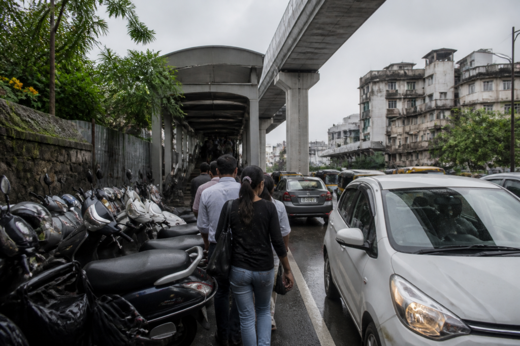
Pune Metro has expanded public transport options between Deccan Gymkhana and Vanaz, but access to several stations remains difficult for the people expected to use the system most: pedestrians. A Civic Mirror inspection and interviews with commuters and mobility advocates describe footpaths narrowed by station entry and exit gates, parked vehicles and other infrastructure, forcing people to walk on the carriageway in busy areas.
The problem is not simply that some footpaths are inconvenient. It raises a larger question about what counts as a complete metro project. A station can move passengers efficiently along its corridor and still remain difficult or unsafe to reach if the surrounding walking network is obstructed. On the Pune corridor, the reported gaps appear around the interface between metro infrastructure, road space, parking management and local street design.
Civic Mirror reported that the difficulties were particularly visible between Garware College and Vanaz, with conditions worsening during peak hours. Pedestrians were described as having to weave around two-wheelers and other vehicles parked on footpaths. In some locations, the absence of a continuous walking path meant that people had to step directly into traffic.
Pranjali Deshpande, who works independently in sustainable transport, identified station access and exit gates occupying footpath space, along with parking on footpaths, as two of the main problems on the route. She said station entrances and exits should open into adequately sized, protected areas rather than narrowing pedestrian space or directing people towards busy roads.
Deshpande cited the exit arrangement at the Jangli Maharaj Road–Balgandharva metro station as an example of an access route opening into a protected space. Her argument is significant because station access is not a minor design detail. It determines whether the metro can be reached safely by people walking from nearby homes, schools, workplaces and bus stops. When access points are placed in already constrained pedestrian corridors, the metro’s benefit can be offset by the risk and inconvenience of the final few hundred metres.
The SNDT metro station junction was identified as a persistent safety concern. According to Deshpande, narrow footpaths and disorderly parking have continued since the station began operating. She also questioned how much space was reserved for other modes of transport when the metro infrastructure was planned. A dedicated cycling route, she said, is absent along the corridor, even though several schools are located nearby.
That gap affects more than cycling as a standalone activity. A child travelling by metro from Vanaz to reach a nearby school would need a safe connection between the station and the destination. Without a protected cycle route or a continuous pedestrian network, the combined use of metro and cycling becomes difficult and potentially unsafe. The issue is therefore one of integration: public transport depends on the quality of the streets that feed it.
The reported conditions also show how competing uses of limited road space can undermine access to mass transit. Social activist Prashant Kanojia raised concerns about restricted road width near the bridge and BSNL area in Kothrud, as well as the planning of metro pillars and related infrastructure. He alleged that future traffic needs were not adequately considered when the structures were planned. He also questioned whether the current pillar arrangement would support a future extension towards Chandni Chowk and whether the possible need for a flyover had been considered at the planning stage.
These allegations have not been independently confirmed through an engineering assessment. They nevertheless point to a recurring planning challenge in built-up corridors: infrastructure is often added within existing road space, while the effects on footpaths, turning movements, parking, drainage and future expansion are considered separately or later. The result can be a project that solves one mobility problem while transferring pressure to adjacent streets.
Kanojia also described the road near the Mot iwala shops close to BSNL as particularly narrow. He raised concerns about traffic management near the bridge, including restrictions on right turns from the Kalmadi and Garware sides. According to his account, some motorists avoid the bridge because of the inconvenience, increasing pressure on the road below. He further expressed concern about a signal on a steep approach after the bridge and the presence of large dumpers. The report does not include an independent traffic or safety assessment of these claims.
Parking is another part of the station-access problem. Passengers arriving by two-wheeler reportedly struggle to find suitable parking near Vanaz, Anandnagar and SNDT. When formal parking is unavailable, vehicles may be placed in unauthorised locations, exposing users to penalties and adding to footpath obstruction. Kanojia proposed using an empty floor at Vanaz station for parking, estimating that it could accommodate between 700 and 800 vehicles. That figure remains an estimate and would require a technical assessment before any decision.
The proposal also reveals the tension between encouraging metro use and managing access to stations. If a commuter cannot safely walk to a station or find a lawful place to park a two-wheeler, the metro journey begins with a practical barrier. Yet adding parking without protecting walking space can create another conflict. The question is not only how many vehicles a station can accommodate, but how access is allocated between pedestrians, cyclists, buses, two-wheelers and private cars.
Drainage and sanitation concerns add a civic infrastructure dimension to the corridor. Kanojia alleged that leaking septic tanks near Vanaz, Anandnagar and SNDT were allowing wastewater to flow onto roads, creating odour and unhygienic conditions for pedestrians. He also said water accumulated near the waste depot beyond Vanaz during the monsoon because of inadequate drainage connections. These claims were reported as concerns raised by him and were not independently verified in the supplied material.
For commuters, the outcome is experienced at street level. Passenger Nikunj Kulkarni said people use the metro to save time, but parked vehicles on footpaths make it difficult to reach the station. Another passenger, Adwait Shastri, said there should be enough space to walk safely near stations, particularly during peak hours, so that pedestrians do not have to enter the road to get around parked vehicles.
The evidence in the report does not establish that every problem has the same cause or that all locations require the same intervention. Some relate to station design, others to parking enforcement, junction management, drainage or the allocation of road space. That distinction matters administratively. MahaMetro controls the metro system and station infrastructure, while footpaths, parking, local roads and drainage may involve other civic and traffic authorities. A fragmented responsibility structure can make it difficult for commuters to identify who must fix a problem that appears at the boundary between agencies.
The absence of a response from MahaMetro is also material. Civic Mirror reported that its additional general manager for public relations and administration, Chandrashekhar Tambvekar, did not respond to telephone calls and messages. The supplied report contains no official explanation of the station-gate design, parking arrangements, proposed corrective measures, drainage complaints or the future capacity of the Vanaz facility.
Pune’s corridor therefore illustrates a broader urban planning test: whether mass transit is being delivered as a line and a set of stations, or as a complete public realm. The metro can provide the rapid middle section of a journey, but the first and last sections remain dependent on footpaths, crossings, cycle routes, parking rules, drainage and traffic design. If those systems are not coordinated, the network’s accessibility is limited even when trains are operating.
What the report confirms is a cluster of pedestrian and access complaints along the Deccan Gymkhana–Vanaz stretch, supported by observations and named commuter and activist accounts. What remains unresolved is the institutional response, the engineering assessment of the alleged road and pillar constraints, and the feasibility of using vacant station space for parking. Those questions will determine whether the corridor’s metro investment is matched by safe, continuous and usable access at street level.