The congestion around the Dapodi–Pimpri-Chinchwad metro corridor is not being caused by metro pillars alone. The reported problem is a wider failure to manage a constrained urban road where elevated infrastructure, station access, parking, auto-rickshaw activity, pedestrian movement, traffic signals and enforcement are competing for the same limited space.
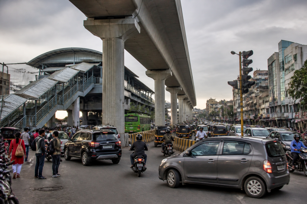
A Civic Mirror report from Pune describes how the old Mumbai–Pune Highway between Dapodi, Pimpri and Chinchwad has become increasingly difficult to navigate, particularly near metro stations and major junctions. Metro pillars stand along much of the road’s central median, but differences in their alignment, barricades around junctions, irregular parking and alleged unauthorised auto-rickshaw stands have narrowed the usable carriageway. Passengers and activists cited in the report say that congestion has intensified even after road dividers were installed around sections of the pillars.
That distinction matters. The transport problem is not simply whether a pillar occupies space in the road median. It is whether the entire street has been redesigned around the new structure, and whether the road continues to function safely for buses, cars, two-wheelers, freight vehicles, pedestrians and metro users. On this corridor, the evidence supplied in the report points to a street where each transport layer has been added or managed separately, without sufficient coordination at the points where they meet.
The geometry of the corridor appears to be a central concern. According to the report, some pillars in parts of Pimpri-Chinchwad are not in a single straight line: some extend further into the road while others are set back. Dividers have been installed around pillars between Pimpri and Dapodi, creating a degree of separation between traffic and the structures. However, the arrangement has not removed congestion at junctions or on approaches to metro stations.
The impact is likely to be most severe at turning points. Large vehicles require more space to turn, and the report identifies locations such as Nashik Phata–Bhosari as places where pillars and associated structures may obstruct vehicle movement. When the effective road width is reduced at a junction, a design that appears manageable on a straight stretch can become a serious operational constraint during turning movements, signal changes and peak-hour surges.
Roadside behaviour compounds the design challenge. The report records allegations that auto-rickshaws stop in the middle of the road regardless of the signal phase, while private cars are also left on the carriageway. At the Morwadi area, identified in the report as Pimpri station, local residents allege that unauthorised auto stands operate on both sides of the road. As many as 25 to 30 rickshaws may gather near the station stairs and access ramps at one time, according to the account cited by Civic Mirror.
This is a classic station-area management problem. A metro station does not end at its platform or entrance. It generates pick-up and drop-off movements, pedestrian crossings, waiting vehicles, informal interchange activity and demand for parking. If those functions are not given designated space, they spill onto the main carriageway. The result is that a project intended to move large numbers of people efficiently can create a local bottleneck at the very point where passengers are expected to transfer between modes.
The reported signal cycle illustrates how quickly this can become a network problem. Vehicles are said to receive only 30 to 40 seconds to move forward after the signal turns green, with rickshaws, station activity and nearby structures leaving limited room for vehicles to pass. When only a small number of vehicles clear each cycle, queues build on the main road and can extend into adjoining junctions. The supplied report does not provide an independent traffic count or a signal-engineering assessment, but it identifies a clear operational concern: road capacity is being consumed by stopping, waiting and access movements rather than through-traffic.
Pranjali Deshpande, identified in the report as a road-design expert, said that parking management near stations was a major issue. Vehicles parked between two pillars can extend into the carriageway, while manoeuvres to enter or exit parking spaces can obstruct footpaths and pedestrian movement. This reveals an important weakness in treating parking as a secondary issue. On a narrow corridor, a single row of poorly managed vehicles can have a greater practical effect than the permanent footprint of a structure because parking also generates turning, waiting and pedestrian conflicts.
The pedestrian dimension is equally significant. The report says that station access points, stairs and ramps are crowded, while parking and auto-rickshaw activity compete with pedestrian space. If footpaths are blocked or narrowed, metro users are pushed towards the carriageway. That increases exposure to moving vehicles and also encourages informal crossing behaviour. The report does not cite accident statistics, so the scale of any increase in crashes cannot be established from the supplied material. It does, however, document a combination of physical and operational conditions that residents and commuters regard as unsafe.
Enforcement has not resolved the problem. Pimpri-Chinchwad Municipal Corporation has made around 1,100 traffic wardens available to assist the police, according to the report. Yet commuter Rishi Phadnis said that adequate action to control traffic was not taking place. He alleged that some wardens focus more on catching rule-breakers than on clearing congestion. This points to a question of institutional purpose: traffic personnel can issue penalties, but station-area congestion also requires active management of stopping zones, pedestrian crossings, loading activity, turning movements and signal operations.
The report also raises questions about how responsibilities were divided during construction. Activist Maruti Bhapkar said that an agreement between the metro corporation and Pimpri-Chinchwad Municipal Corporation required the metro agency to prevent potholes, traffic obstruction and accidents during the project. He alleged that these responsibilities had not been adequately fulfilled. These are attributed allegations, not independently established findings in the material supplied, but they identify the accountability gap that often emerges when a major infrastructure project occupies an existing public road.
A metro corridor can be delivered by one agency while the surrounding road remains under the control of a municipal corporation, traffic police, parking authorities and local enforcement teams. Station access may involve yet another set of responsibilities. Without a single operational plan for the corridor, each agency can complete its formal task while the combined system performs poorly. A pillar may meet structural standards, a station may open on schedule and traffic wardens may be deployed, yet commuters can still face unsafe and congested streets because no institution is accountable for the whole street environment.
The report further connects the current road conditions to earlier public investment. Bhapkar questioned the use of public funds on bus stops and other infrastructure built for the Bus Rapid Transit System between Nigdi and Pune station, arguing that some of those facilities became ineffective after metro construction began on the highway. He also proposed locating a metro alignment alongside the Lonavala–Pune railway corridor, with stations near existing railway stations, as an alternative that could have reduced disruption to highway traffic. The report presents these as his views; it does not provide a comparative feasibility study or cost assessment for the alternative alignment.
That debate illustrates the long-term planning issue behind the immediate traffic jam. Alignment decisions are not only engineering choices. They determine which roads lose space, which neighbourhoods gain access, how much land must be acquired, whether existing bus infrastructure remains useful and how easily passengers can transfer between rail, metro, buses, rickshaws, private vehicles and walking routes. Once elevated structures and stations are built, correcting the surrounding street design becomes more expensive and politically difficult.
The Dapodi–Pimpri-Chinchwad corridor therefore offers a broader lesson about urban transport delivery. Metro capacity cannot be measured only by trains, stations or route length. It also depends on the quality of the last few hundred metres around each station. If access roads are blocked, if parking is unmanaged, if informal stands occupy the carriageway and if pedestrians lack continuous space, the system’s public value is reduced even when the rail infrastructure itself is operational.
The evidence in the report confirms a layered problem: uneven pillar geometry in some stretches, constrained junctions, station-related crowding, informal stopping, parking spillover, short signal windows and concerns about coordination between the municipal corporation, metro authorities and traffic police. It does not establish the precise contribution of each factor, nor does it provide verified accident data or an official response from the agencies named. Those gaps make a detailed corridor audit important before assigning responsibility for individual incidents or design decisions.
The immediate administrative question is whether the agencies responsible for the corridor can treat it as one integrated street rather than a collection of separate assets. That would require the next steps to be visible in the form of junction reviews, station-area access management, designated auto and pick-up zones, parking enforcement, pedestrian protection and a clear account of how construction and operating responsibilities are being discharged. Until then, the metro pillars will remain the most visible feature of a problem that is ultimately about how a city manages shared road space.