

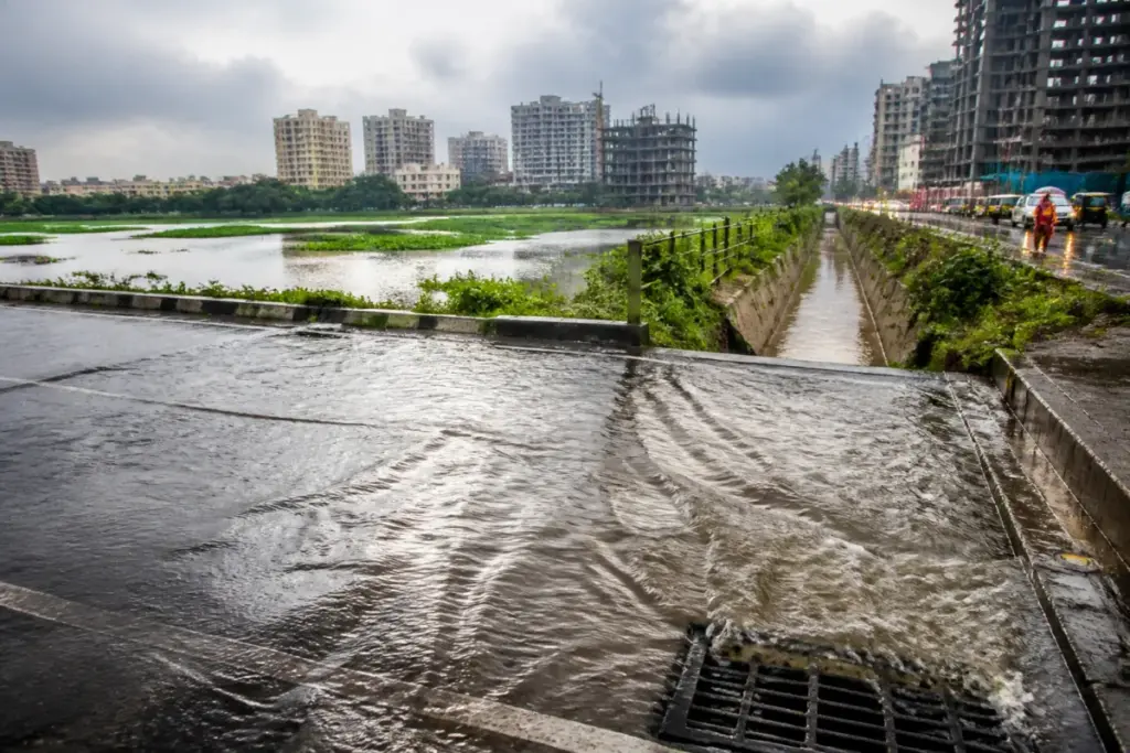
Bengaluru’s groundwater crisis is no longer only a story about too many borewells. A new study shows that the city is extracting groundwater at more than twice its annual extractable resource while its expanding built-up surface is sending increasing volumes of rainwater away as runoff. The result is a water paradox: Bengaluru can flood during intense rain and still fail to replenish the aquifers beneath it.
The study, From Crisis to Resilience: Rethinking Urban Flooding and Groundwater Recharge in Bengaluru City, was published in World Water Policy in 2026. It examines 27 years of rainfall data from 1997 to 2023 alongside long-term groundwater records. Its central finding is that the city’s water insecurity is being produced by two connected processes: groundwater extraction is rising, while the urban landscape is losing the open and permeable spaces needed to absorb rainfall.
According to the research, groundwater extraction in 2023 was estimated at 4,627 hectare-metres, against an annual extractable groundwater resource of approximately 2,128 hectare-metres. That places the stage of groundwater extraction at about 217%. In practical terms, the city is drawing substantially more groundwater in a year than the quantity estimated to be available for annual extraction.
The figures do not describe a temporary imbalance caused by one dry season. They point to a structural mismatch between the city’s water demand and the capacity of its groundwater system. The research attributes the growing dependence on borewells particularly to peripheral areas where municipal water supply is inadequate. At the same time, the surfaces that could help recharge groundwater are being reduced by roads, buildings, paving and other forms of construction.
This is where Bengaluru’s flooding problem becomes inseparable from its groundwater problem. Between 2000 and 2020, the city’s built-up area increased from about 42% to 86%, while vegetation declined sharply, the study says. Open soil, unpaved roadside verges, vegetated areas, natural drainage corridors and other permeable surfaces have increasingly been replaced by hard surfaces. Some rajakaluves, or natural drainage corridors, have also been narrowed or obstructed.
The hydrological effect is straightforward. Rain falling on a permeable surface can be held temporarily and infiltrate into the soil. Rain falling on concrete or asphalt is more likely to move rapidly across the surface and enter drains or low-lying areas. The study found that runoff from built-up areas increased by about 105% in 2020 compared with 2000. Over the same period, runoff contributions associated with vegetated areas declined by approximately 82.4%, while those associated with open areas fell by 67.6%.
These changes help explain why more visible stormwater does not necessarily translate into more groundwater. A flood is evidence of water moving through the city, but not of water being stored in the aquifer. When rainwater is converted quickly into surface runoff, it can overwhelm drainage systems while contributing less to local recharge. The urban landscape therefore becomes vulnerable at both ends: it experiences excess water during rainfall and scarcity when groundwater is needed.
The study also finds that Bengaluru’s groundwater system has not become completely disconnected from rainfall. Dr S Biswas of the Central Ground Water Board, Ministry of Jal Shakti, one of the study’s authors, said the long-term analysis showed that groundwater levels often responded most clearly one to two months after rainfall, particularly in some wetter years. That observation is important because it indicates that rainfall can still support groundwater recovery, but the opportunity depends on whether water is allowed to remain in the landscape long enough to infiltrate.
The challenge is therefore not simply the amount of rain Bengaluru receives. It is the relationship between rainfall, land cover, drainage and extraction. A city may receive substantial rain and still experience groundwater stress if its catchments have been built over, its drainage corridors interrupted and its recharge spaces fragmented. The study’s evidence connects these elements rather than treating flooding and borewell dependence as separate civic problems.
Bengaluru’s lake system illustrates why individual infrastructure assets cannot be considered in isolation. The researchers describe the city’s lakes as historically interconnected water bodies linked by tanks, catchments and rajakaluves that broadly followed the natural topography. These systems stored monsoon runoff, slowed its movement downstream, reduced flood peaks and, where local hydrogeological conditions allowed, created opportunities for groundwater recharge.
That history also changes the meaning of lake protection. Protecting a lake without protecting its catchment, buffer areas and connecting drainage corridors leaves the wider water system exposed. A lake may remain visible while the landscape that feeds it is paved, narrowed or obstructed. Similarly, restoring a drainage channel without addressing the surrounding loss of permeable land may move water faster without restoring the recharge function that the city needs.
The study’s findings place small and dispersed spaces within the larger water-management picture. Gardens, vacant plots, roadside verges, bioswales and other vegetated patches may each appear insignificant compared with a large lake or a major stormwater drain. Collectively, however, they can slow runoff and create local opportunities for infiltration. Their decline is part of the city’s changing hydrology, not merely a loss of greenery.
This has administrative implications because the water cycle does not follow the boundaries of individual projects or agencies. Groundwater extraction, municipal water supply, stormwater drainage, lake management, road construction and land-use change affect the same catchments. The research describes fragmented governance as one of the factors shaping Bengaluru’s water security. The problem is consequently not only whether a particular drain is cleared or a particular lake is restored, but whether the connected system is being managed as a connected system.
The numbers show the scale of the shift. Built-up area more than doubled as a share of the city between 2000 and 2020, rising from about 42% to 86%. Runoff from built-up areas rose by about 105% over the same period. Meanwhile, the estimated 2023 groundwater extraction level reached 217% of the annual extractable resource. These figures describe a city in which urban expansion has increased the speed at which rainwater leaves the surface while demand has increased the rate at which groundwater is removed.
The evidence does not establish that every flood event is caused by groundwater extraction, nor that every borewell has the same effect. It does show that the two issues are linked through land-use change and the loss of recharge opportunities. It also indicates that groundwater levels can respond to rainfall with a delay, which makes the condition of the intervening landscape significant. If rainfall is diverted rapidly as runoff, the delayed recharge response becomes harder to sustain.
For Bengaluru, the larger urban question is whether water infrastructure will continue to be planned as separate assets or as a landscape system. Lakes, rajakaluves, open areas, vegetation, roads, buildings and borewells operate within the same hydrological network. The study’s findings suggest that a city can undermine its groundwater security even while expanding drainage capacity, if the underlying loss of infiltration space continues.
The research confirms a severe imbalance between groundwater extraction and annual extractable resources, alongside a measurable increase in runoff from built-up areas and a decline in the contribution of vegetated and open spaces. What remains to be established from the supplied material is how these findings will be translated into specific administrative measures. The developments that merit close monitoring are the protection of catchments and drainage corridors, the treatment of smaller permeable spaces as part of water infrastructure, and the management of borewell dependence in areas without adequate municipal supply.


